
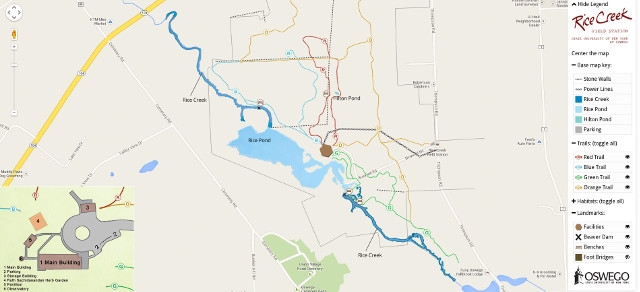
SUNY Oswego has unveiled a new interactive, interpretive map for Rice Creek, the college`s 400 acres of streams, fields, marshes and a biological field station south of the main campus.
"Visitors can explore the clickable, interactive, color-coded map and learn more about Rice Creek trails and features to plan a visit, find their way along the trails or to document course projects and research," said Diann Jackson, assistant director of the field station.
Jackson said the new map could be customized to show one trail or one habitat at a time, as well as locations of benches, footbridges and other landmarks.
"Using a mobile device, it can be used instead of a paper trail map, and that is very good for our environment," she said. "We will continue to add more pop-ups with photos and information about the trails and encourage visitors to send photos of Rice Creek to share."
Jackson conceived of the online map more than two years ago and worked to create it with assistance from the college's Office of Public Affairs. Joe Fitzsimmons, associate web developer, and Pat MacNeill, web coordinator, in the Public Affairs Office helped bring the map to fully functional reality. Fitzsimmons said the map utilizes Google Maps' application programming interface and the talents of other developers and graphic design students.
"I am a native of Oswego and went there (to Rice Creek) in grade school and high school," Fitzsimmons said. "I guess it's something I always wished I had access to -- an interactive map. So it was nice to work on this and help make it a reality."
Rice Creek and its biological field station are located off Thompson Road, about a mile south of the main college campus.
The map can be found at www.oswego.edu/ricecreekmap.
